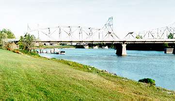
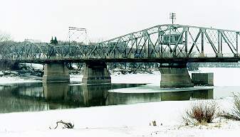
 19. 11. Because of the above-average temperature, the Red River remained open
under the Winnipeg bridges until the end of December. This is another one of
the older Winnipeg bridges, the Redwood Bridge, which apparently remembers the
end of the era in which the Red River was the main traffic artery, along
which the goods and people were moved, especially before the railway came
to the city, from the south from Minnesota. It is a highway bridge now, but
there are old rails hidden under its pavement as it has been revealed during
its repair earlier this year. This bridge allowed the passage of big ships after
its middle portion was rotated by 90o. The engine room that
rotated the bridge is situated in that box high above the bridge pavement.
The room was powered through the external wires supported by the pole sticking
above the engine room. This pole had to be rotated at the same speed but in
the opposite direction than the bridge itself to stabilize the wires.
(There is another, long ago decommissioned, railway bridge
of this type a few kilometers further north.)
19. 11. Because of the above-average temperature, the Red River remained open
under the Winnipeg bridges until the end of December. This is another one of
the older Winnipeg bridges, the Redwood Bridge, which apparently remembers the
end of the era in which the Red River was the main traffic artery, along
which the goods and people were moved, especially before the railway came
to the city, from the south from Minnesota. It is a highway bridge now, but
there are old rails hidden under its pavement as it has been revealed during
its repair earlier this year. This bridge allowed the passage of big ships after
its middle portion was rotated by 90o. The engine room that
rotated the bridge is situated in that box high above the bridge pavement.
The room was powered through the external wires supported by the pole sticking
above the engine room. This pole had to be rotated at the same speed but in
the opposite direction than the bridge itself to stabilize the wires.
(There is another, long ago decommissioned, railway bridge
of this type a few kilometers further north.)
|